On the Roof of Vietnam


Lai Chau, 1200 km from the start
I'm in a small, dusty town on a road to almost nowhere. I've put up for the night in a cheap but dubious-looking hotel that seems to double as a brothel, as many cheap hotels do around the world. It wasn't the only choice in town, but they all seem pretty similar.
So I'm a day down the road from Sapa, the tourist mecca of northern Vietnam, where I spent a couple of nights, before and after climbing Fansipan, the highest peak in the country. I took two surprisingly quick and easy days to get to Sapa from Bac Ha. The first was mostly downhill and flat, which was just as well as my destination city, the border town of Lao Cai (border with Yunnan province, China) was an absolute oven by the time I arrived at lunch time. There were a lot of Chinese tourists in town, riding around in numbered buses, wearing matching flourescent baseball caps and looking bemused. Now group tourists often look bemused, as they seem to switch their brains off as they enter the tour bus, but these tourists looked particularly befuddled as there's precisely nothing of interest in Lao Cai. I hope they were at the start of a longer tour going to other places in Vietnam, because otherwise it would have been a rather dull visit to the country.
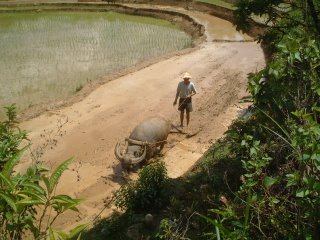
The next day I set off very early for a long climb to Sapa. Lao Cai is at about 100 metres above sea level and Sapa is at about 1450 metres, so it was clear that the road was going to be up, up, up. As I got going by 6:30, it was humid but not too hot, and I got up to an altitude where it was slightly cooler and breezier by 9 am. It was a perfectly paved road, and I could see why the government had spent so much effort on it. I was passed by at least 40 minibuses transporting tourists up to Sapa from the Lao Cai railway station. I also met my first bicycle tourist since Cat Ba island, a member of a Kiwi mountain biking group; the other members were taking trails down to Lao Cai, but she had had a crash the day before and decided to stay on pavement. The views were lovely, looking out at complex systems of rice terraces that are just being flooded now for planting. Seen from above, the water shimmers and looks quite strange, intersected as it is by all the terrace walls. From time to time I saw farmers riding wooden sleds behind water buffalo as they smoothed out the mud in the terraces. Before I knew it, I had covered the 38 kilometres to Sapa and was back in the land of mass Western tourism: endless souvenir shops, banana pancakes on the restaurant menus and several faux-French upscale restaurants lining the main street.
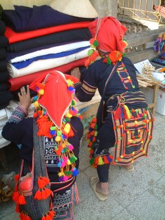
Sapa is a market centre for the surrounding highlands, and you see members of the local Montagnard tribes in town to buy and, in particular, to sell souvenirs to tourists. The two biggest tribes in the Sapa area are the Dao and the Black Hmong. The Dao women wear enormous red headdresses and shave their hairlines to accentuate the size of their round faces. It's quite an unearthly look, reminiscent of old Flemish portraits. The more numerous Black Hmong women wear indigo-dyed shirts, aprons, shorts and leggings, and enormous silver earrings and necklaces. Interestingly, the Black Hmong men also still wear traditional indigo trousers and shirts, unlike the men of most tribes who wear Western dress. The Black Hmong must surely be among the shortest ethnic groups on the planet. Lowland Vietnamese are already slight, tiny people, but they absolutely tower over the Black Hmong. I would guess the average height of the women to be about 4 foot 9, with a lot of older women significantly shorter. From a distance, some of the women look as though they must be about 9 years old, until you realize that they have a baby on their back. Swarms of Hmong women surround tourists on the street, trying to sell jewellery and weaving and, if that fails, hashish and opium.
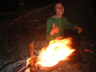
I spent an afternoon wandering around and taking pictures of the fabulous outfits, and then booked a guide to climb Mt. Fansipan, the 3142-metre mountain that towers over Sapa. It was a wonderful, leisurely 3-day climb (it could easily be done in 2 days, or even 1 very, very long day, but I was feeling lazy). My guide and I climbed for 4 hours up to the base camp on the first day, through an enormous area of forest that burned down 20 years ago and is only slowly regenerating. Camp was in a lovely forest glade beside wonderful swimming holes; if only the guides and camp maintenance people didn't turn the area into an enormous garbage dump and build the camp toilet directly over a stream!
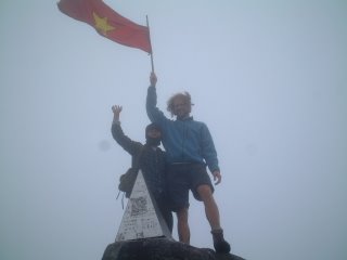
The next morning we marched off under cloud and rain to the summit. It was a remarkably steep ascent, up limestone faces covered in dense rhododendron forest, clinging to exposed roots and rock faces for balance. Some of the trees were blossoming, making for beautiful surroundings. After a while we entered dense bamboo groves and finally open grassy areas before reaching the fog-enshrouded peak. No views at all, but the walk was lovely. It took us longer to descend (3 hours 20 minutes) than to ascend (2:50) as it was so slippery underfoot that we ended up sitting down and picking our way down on our butts.
The third day we awoke to pouring rain and set off late downhill. It was even more slippery on the return path, which took a different route than the ascent. As the heaviest member of the group (I had joined an Austrian couple and their guide), I fell much more than they did, and was quite frustrated and sore by the time we got down to the river. We had great views though as we walked down an exposed ridge, looking at the other high peaks in the area.
I was pretty sore by the time I got to Sapa, mostly from preventing myself from falling, and so I was glad to get back on the bike for the first time in 4 days. Today's ride was pretty vertical, with a climb to a 1930-metre pass, a huge downhill through lovely scenery, and then another long, hot climb to a 1300-metre pass before coming downhill to this point. When I heard that I had another pass between me and my intended overnight stop, I decided that I'd had enough for the day and found my dubious hotel. It was another hot day; 41 degrees at noon. I was hoping that the mountains would cool down the air, but no such luck. The tribes around here are different than in Sapa, including some whose women wear black turbans with huge silver dishes on top that makes them look like cartoon Martians. Lots of rice planting going on
So now the plan is to make it to Dien Bien Phu, the remote spot where the Viet Minh guerrillas destroyed a French army in 1954, in another 2 days, and then head down to the coast south of Hanoi for some flat, easy cycling along the coast. I anticipate lots more sweaty climbs before I get to the beaches along the coast. I'm looking forward to more views of rice terraces, limestone peaks and colourfully-dressed tribal women before I return to modern Vietnam.
So until I find another working internet connection, I hope that May finds you all happy, healthy and having more fun than a barrel of monkeys. Or than a Canadian cyclist in Vietnam.
Tam biet!

0 Comments:
Post a Comment
<< Home